Tonight we will be learning about basic archaeological recording methods through a practical hands-on workshop led by a Rowena Hart (GGAT Projects Officer).
By the end of this session the group members will be have the skills to produce a visual record of an archaeological site that comprises a brief written statement, photography and measured drawing.
The principles taught in this session will be put into practice in next Fridays session on site.

Thursday 27 October 2011
Tuesday 25 October 2011
Tape problems
Paul, Sad man that I am.
I've been thinking about the tape we were using. as it starts at 10cm we would have to reduce the measurements shown by the tape, not add another 10cm (effectively the error is 20cm).
So the first measurement (longest side to the left looking from the tower) is OK, because I took 10cm off. All the others along the back the far right triangle are all 20cm too long. Hope this makes sense and that I caught you before you started drawing?
Andy Brown


Friday 21 October 2011
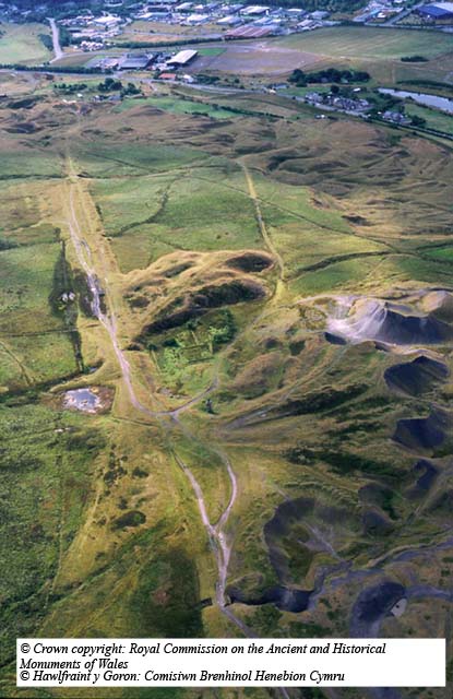
A walk to hill pits
 On a dark overcast Friday in October we made our way from the Blaenavon World Heritage Centre. Our first stop was the Pwll Ddu Tunnel (SAM:223) entrance near the Blaeavon to Brymawr road. Ascending the near-by bank we made the short steep climb to where the remains of the base of a stone walled house, which have been fenced off. These remains are all that is left of a property belonging to the engine brakeman.
From there we made our way to the old Powder House (a Grade I Listed Building) that looks like the remaining side is about to collapse at any time soon!! We then made are way to Hill's pit chimney and enclosures. Once there we took measurements of the remaining enclosure banks, which will then be plotted onto a map.
Exposed to the elements and left to nature the remains of these stone built enclosure banks take on a natural feel like the surrounding area that once was a hive of activity, now laying dormant.
It is the aim of this group through researching various media to collect and correlate the information along with archaeology surveys to once more to expose and to bring to life what it must have been like to had lived and worked during the time when these enclosures were in use.
Michael Tomboline


Session 4: The Way of the Archaeologist-Site visit
Don't forget we'll be meeting on Friday 10:30am this week! We'll meet at the World heritage Centre before driving up to the car park by the Pwll Du tunnel. This session will be our initial sit visit, so we'll walk past some of the sites we've discussed during the sessions, finally finishing at Hill's Pit.
Once there we'll carry out a written and photographic survey of the site and discuss what will take place during the topographic survey on the 4th November. See you all there.

Thursday 13 October 2011
And then there were four
Last week we identified the Hill's Pit area to concentrate our study on. We met back at the Heritage Centre this session having completed some research of our own through the week. There appears to be a great deal of information out there, but the task will be collating and editing this for the HER.
From Michaels rummaging in the archives at the World Heritage Centre we have been able to update the HER record for the main Hill's Pit air shaft.
Using a GIS mapping system we have identified that of the features we will be studying, however, the only information on the GGAT HER is for the air shaft (at present) and so our work will help to increase the information that is available to the public on this site.
Andy Brown
Session 3: Archaeology Show and Tell

This week we will be creating new and updating historical records through shared memories, personal histories, old photographs and sketches. Hopefully!
Remember, we are back at the World heritage Centre. 7-9pm
Friday 7 October 2011
Thanks
A big 'thank you' to Mike Howell for letting use the facilities at the Communities First building and apologies to the Arts and craft class that we pushed out of their regular Thursday night spot.
Also, thanks to Andy who made us all tea and coffee at break during yesterdays session. Tea making is an essential skill for any archaeologist!
See you all next week back at the World Heritage Centre...except for Katie who's going to see Bob Dylan.

Also, thanks to Andy who made us all tea and coffee at break during yesterdays session. Tea making is an essential skill for any archaeologist!
See you all next week back at the World Heritage Centre...except for Katie who's going to see Bob Dylan.

Thursday 6 October 2011
Exploring Your Heritage, Week 2, 6 Oct 2011
Today we were at the Pavillion (Communities First) with tutors Paul Huckfield (Outreach Officer), and Charina Jones (Historic Environment Record Manager) at GGAT.
We started by deciding that it would be best to investigate 1 of the 6 mentioned sites mentioned last week - Hill's Pit enclosures (we may be more sheltered from the weather).
After an introduction we searched for information according to the worksheet - using the Archwilio database, http://www.cofiadurcahcymru.org.uk/arch/ggat/english/ggat_interface.html . We searched for things like St Peters School, and the scheduled monuments and listed buildings (in Legal Protection column). This was designed to give us practice in record searching, we can now go off and search to our heart's content.

Then we went on to Map regression: had a look at copies of the 1st, 2nd and 3rd edition Ordnance Survey maps of the Blaenavon area (spelt with an 'f' on 1st edition OS). We also had a look at a tithe map from circa 1820s and the information it gives (land ownership, use etc.).
To prepare for next week, where we'll be looking at adding and updating Historic Records, we were asked to research any sites where we can add more information for. Particularly investigate the current information available for Hill's Pit Enclosures.
Dennis Hopkins

Session 2: Landscape detective
 Tonight's session will look at the evolution of landscape, find out how maps are used in archaeology and historic landscape studies. We'll also explore the methods archaeologists use to identify new sites, have a go at interpretation of cartographic information, plotting information onto base maps and storing results on an electronic database.
Wednesday 5 October 2011
Course Details
The course runs over 10 weeks and covers such topics as:
· What’s in my area? Learn about the rich and diverse archaeological resource in the Blaenavon World Heritage area.
· Landscape detective Understand the evolution of landscape, find out how maps are used in archaeology and historic landscape studies. Have a go at interpretation of cartographic information plotting information onto base maps and storing results on a electronic database.
· Community Archaeology Show and Tell Create new historical records through shared memories, personal histories, old photographs and sketches.
· The way of the Archaeologist Learn basic archaeological recording methods through a practical hands-on workshop led by a recording specialist. Produce a visual record of an archaeological site, comprised of a brief written statement, photographs along-side measured drawings.
Subscribe to:
Posts (Atom)